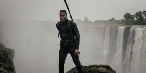
Young visionary embarks on a quest to put Zimbabwean streets on Google Street view

Tawanda Kanhema, a digital strategist and photographer who moved from Zimbabwe to California in 2009, spent the better part of last fall working to correct this imbalance. As Aloysius Low reports for CNET, the Berkeley resident teamed up with Google and photography company Insta360 to organize a two-week mapping trip of his home country.
He personally funded all travel and production costs—in total, roughly $5,000—but used a 360 camera loaned by the tech giant.Thanks to Kanhema’s efforts, Street View now features more than 500 miles of coverage in Zimbabwe.
Per CNET, the footage includes snapshots of Victoria Falls, Harare’s main business districts, the Great Zimbabwe National Monument, and an array of other tourist attractions and urban centers.“When you look at Street View, you’re looking at this mosaic of images that show how people live across the world, how people conduct commerce, how people get around,” Kanhema tells NPR. “I found it quite jarring that a lot of the countries in the region were not on the map. … We should do more to make sure that those communities are represented.”
To capture panoramic views of Zimbabwe’s cities and countryside, Kanhema traveled by car, speedboat, ATV, bicycle and helicopter. Ultimately, he covered a distance of some 2,000 miles.According to CNET, Kanhema’s favorite part of the project was mapping the Zambezi Valley. After mounting an Insta360 Pro 2 camera to a speedboat’s bow, he and his team sailed about a mile down the river, capturing footage of an elephant and a herd of hippos along the way.Kanhema, who grew up in Zimbabwe’s capital city of Harare, tells CNET the experience “was like rediscovering the country all over again.”He adds, “I’m glad to be able to capture a snapshot that will allow us to look back and see where the cities go from here. I get emails from Zimbabweans abroad who want to show their kids the streets they grew up on on Street View and I realize that there are not many ways to preserve those memories and the visual ethnography of a city.”Google Street View currently boasts tours of locations on all seven continents, but vast stretches of Africa, the Middle East and Asia remain unmapped. As Stafford Marquardt, a product manager for Street View, says to NPR, this trend stems from Google’s prioritization of “large metropolitan areas where we know we have users, where it’s easy for us to drive and we can execute quickly.”Craig Dalton, a geographer and global studies expert at Hofstra University, further explains, “Google Maps is not a public service.
Google Maps is a product from a company, and things are included and excluded based on the company’s needs.”Per the platform portal, Street View relies heavily on user-contributed content, although Google does boast its own fleet of cars, trekkers, trolleys, snowmobiles and three-wheelers. The company doesn’t compensate volunteers, leaving them to fund mapping expeditions out of their own pocket or seek funding from outside parties, including tourism boards and travel agencies. (The Mushkegowuk Council, for example, hired Kanhema to map around 400 miles of northern Ontario earlier this year.)
Speaking with the BBC, Kanhema says he views his work as a “contribution to the ongoing efforts to market the country, … to create visual assets that help Zimbabwe compete with its peers as a tourism destination.”He concludes, “The pace of technology is fast, but adoption can be very slow in some parts of the world, so I wanted to help accelerate [that process].”


